Stormwater management is a critical component of environmental protection, especially in areas affected by construction and infrastructure development. U.S. state departments of transportation (DOTs) have implemented best management practices (BMPs) and post-construction stormwater control measures (SCMs) to minimize the environmental impact of stormwater runoff. Inspecting these practices requires a large amount of manual labor; however, unmanned aerial systems (UAS) are increasingly being used to enhance inspections, and they offer efficient, cost-effective and comprehensive data collection.
The Clean Water Act of 1972 set water quality standards and limits on pollutant discharges, which made stormwater management an essential responsibility for state DOTs. Construction BMPs and post-construction SCMs are designed to manage stormwater runoff and reduce pollutants. Inspections ensure these practices function effectively.
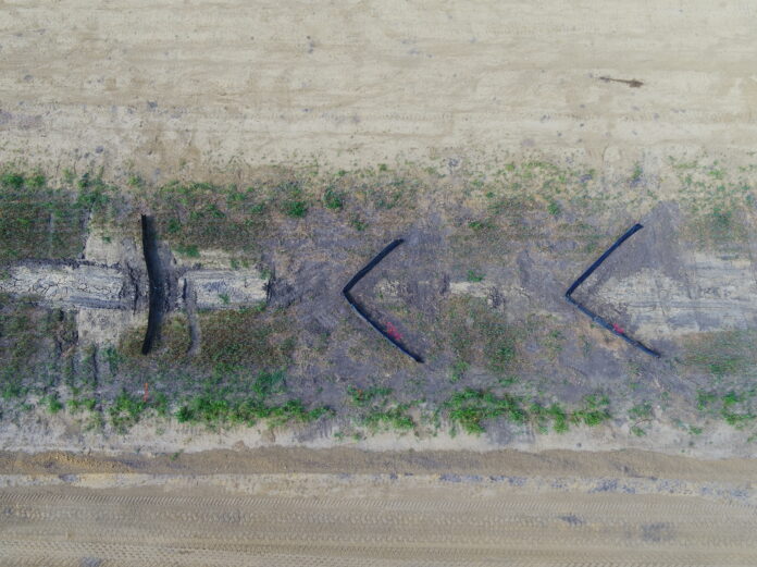
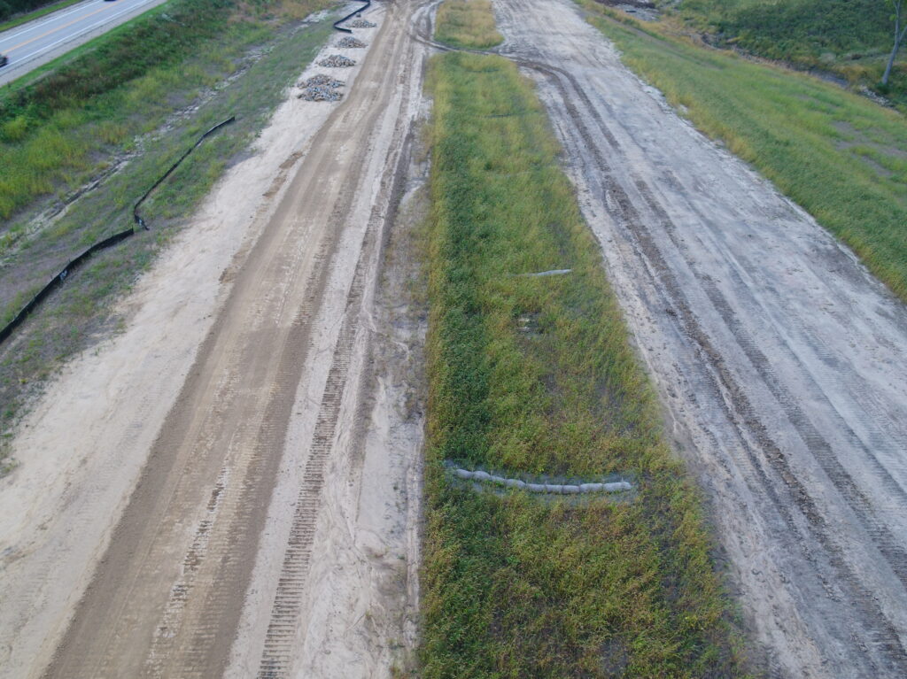
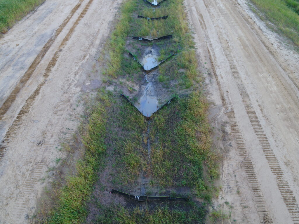
UAS technologies have been adopted by some state DOTs to inspect BMPs and SCMs more efficiently. These drones can capture aerial imagery and detailed data, even in difficult-to-reach areas, which reduces on-foot inspections (Figures 1, 2 and 3). UAS can be equipped with sensors, such as optical cameras and Light Detection and Ranging (LiDAR) cameras, which enable comprehensive assessments of stormwater practices.
Current Use of UAS Technologies by State DOTS
A survey conducted of state DOTs by the authors revealed that UAS technologies are increasingly being used for environmental assessments and stormwater inspections. Forty-six percent of the responding state DOTs use UAS for environmental site assessments or permitting, while 29% specifically use them for stormwater inspections.
Challenges remain in implementing UAS programs for stormwater inspections. Regulatory requirements, including those set by the Federal Aviation Administration (FAA), impose restrictions on UAS operations, such as maintaining a visual line of sight and avoiding flights over people and vehicles. Also, the lack of trained personnel and guidance on effectively implementing UAS technology hinders widespread adoption.
Applying UAS Technologies to Stormwater Inspections
State DOTs that have established UAS stormwater inspection programs use the technology primarily to verify the installation of BMPs and to assess factors such as vegetation establishment, soil erosion and sediment deposition. These inspections are typically conducted shortly after the installation of stormwater BMPs to ensure proper functioning and compliance with environmental standards.
The frequency of UAS use varies among state DOTs. While some, like the Alabama (USA) DOT, utilize UAS technology extensively for USA BMP inspections, others use it less frequently due to staffing limitations and regulatory requirements. UAS technologies are often deployed in combination with traditional on-foot inspections, particularly at sites with restricted access or environmental sensitivity.
Staffing and Equipping a UAS Inspection Program
Establishing a UAS stormwater inspection program requires staffing and equipment. The survey found that state DOTs rely on a mix of in-house personnel and third-party contractors to conduct UAS inspections. However, the lack of trained personnel poses a major challenge. Training programs are crucial to ensure that staff can operate UAS and analyze the collected data effectively.
Most state DOTs use rotary-wing UAS platforms, such as quadcopters, that are equipped primarily with optical cameras. Other sensor types, including LiDAR, thermal/infrared and multispectral sensors, are used, although less commonly. When selecting UAS equipment, state DOTs consider factors such as cost and regulatory compliance, and they balance the need for advanced capabilities with financial and legal constraints.
Data Management and Applications
UAS inspections generate large volumes of data, which requires effective processing, analysis and storage. The primary use of UAS data by state DOTs is to monitor maintenance needs for stormwater BMPs and SCMs, and state DOTs incorporate aerial imagery into inspection reports for clearer communication with maintenance personnel and contractors. However, managing UAS datasets poses a challenge due to their size and complexity.
Some state DOTs have integrated UAS inspection datasets into their existing asset management systems, which allows for more streamlined tracking and prioritization of maintenance activities. Also, artificial intelligence (AI) algorithms are being explored to automate data analysis, which potentially will improve the efficiency of stormwater inspections by identifying deficiencies and assessing overall condition status.
DOT Case Studies: Implementing
Several U.S. state DOTs have successfully implemented UAS technology into their stormwater inspection programs.
- Alabama DOT. The Alabama DOT has a dedicated UAS section in its Maintenance Bureau that conducts UAS-based stormwater inspections. They use fixed-wing and rotary-style UAVs to gather pre- and post-construction video datasets, which document conditions and deficiencies. UAS inspections are conducted at least once every six weeks, with imagery stored in a cloud-based platform. The Alabama DOT plans to increase the frequency of UAS inspections and is developing UAS technologies to identify vegetation density and health.
- Colorado DOT. The Colorado DOT uses UAS technologies for less than 10% of their stormwater inspections. They began exploring AI applications to analyze UAS-acquired photographs for identifying damaged sediment fences and other BMP deficiencies. The goal was to reduce the need for on-foot inspections by using UAS to capture imagery and process data on-site, which identifies deficiencies and maps their locations. However, challenges emerged, and the Colorado DOT decided not to pursue the development of AI applications.
- Delaware DOT. The Delaware DOT primarily outsources UAS inspections to consulting firms due to a lack of trained in-house personnel. They use UAS technology for large linear highway projects, and they capture aerial imagery and videos to supplement traditional inspection reports. The DOT uses a smart device application for on-foot inspections, but it doesn’t integrate UAS imagery into the software.
- Kansas DOT. The Kansas DOT uses rotary-wing UAS technologies for stormwater BMP inspections during construction on large projects. Due to limited staff to conduct UAS operations, flights are not pre-planned, and data processing is manually performed. Aerial images are uploaded to a cloud-based platform and used to create orthomosaic maps for comparing on-foot inspection notes, particularly for evaluating erosion and sedimentation.
Challenges and Future Directions
While UAS offer numerous benefits for stormwater inspections, challenges remain in implementation, data management and regulatory compliance. Staffing shortages and the need for trained personnel are major obstacles, along with the complexity of managing large UAS datasets. State DOTs must also navigate FAA regulations that limit UAS operations, particularly in urban environments.
State DOTs can explore strategies such as offering certification incentives, enhancing recruiting efforts and developing training programs with educational institutions. Cloud-based software solutions can assist in managing UAS data, while AI algorithms can automate data processing and analysis. Advocating for regulatory flexibility and demonstrating the effectiveness of UAS-based inspections can help gain acceptance from environmental agencies.
Conclusion
The integration of UAS technologies into stormwater BMP inspections represents a sizable advancement in environmental management practices. By providing efficient and comprehensive data collection, UAS enables state DOTs to enhance the effectiveness of stormwater management and compliance with environmental regulations. Despite challenges related to staffing, data management and regulatory compliance, the benefits of UAS, such as cost savings, improved inspection quality and enhanced documentation, are driving their adoption.
As technology and regulatory frameworks evolve, UAS are poised to become an indispensable tool for stormwater management and to contribute to the sustainable development of infrastructure and protection of the environment.
Acknowledgments
This paper is based on a study sponsored by the National Cooperative Highway Research Program. (See bit.ly/4jfPh1k.) The authors gratefully acknowledge this financial support. The findings, opinions and conclusions expressed are those of the authors and do not necessarily reflect the view of the sponsor.
About the Experts
- J. Blake Whitman, Ph.D., PE, CPESC, is an assistant professor in the Department of Biosystems Engineering and Soil Science at The University of Tennessee – Knoxville.
- Michael A. Perez, Ph.D., PE, CPESC, is an associate professor in the Department of Civil and Environmental Engineering at Auburn University.

