
This is the time of year when many folks are planning to head to the woods or the beach for a summer vacation, so here are a couple of studies in those areas.
Beach Protection
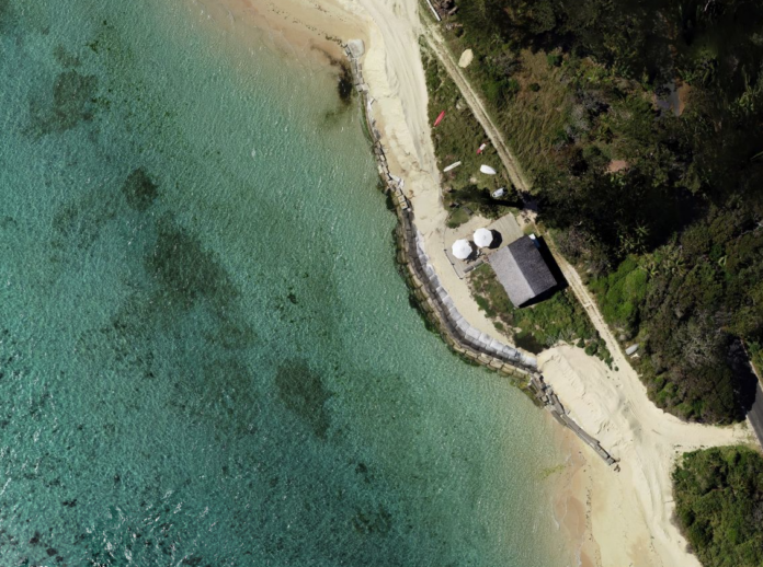
Beach nourishment is a common practice in which sand is added to an eroding beach as a way to reverse the erosion process at least temporarily, often to protect property and maintain recreational value. This process was initiated for a beach on an island 500 km off the coast of Australia in order to protect a vital road, and the transformation and stability of the nourished beach was monitored for a year after completion.2
The project involved moving sand from the northern part of a 1.34 km lagoon beach to the southern part, along with the removal of a dilapidated seawall and a building at the southern end. The lagoon has relatively low wave energy due to protection provided by sandbars and reefs. A commercial unmanned aerial vehicle (UAV) was deployed to survey the area before, during and after the sand was moved and for a year afterward. The photos were used to develop 3D orthomosaics from which changes to the beach topography could be determined.
A local resident was trained to perform the automated UAV surveys, which was critical due to travel costs and restrictions due to COVID. The survey results indicated that approximately 8,200 m3 of sand were moved, close (4% less) to the estimate based on truck volumes. At the end of the monitoring, 71% of the sand moved remained on the south beach (Figure 1). In addition, a new dune structure was established and vegetation was colonizing it. The slope of the middle and south ends of the beach declined, possibly due to accretion during the period. The authors found that the use of relatively simple and inexpensive commercial UAVs can be a valuable tool for monitoring similar types of projects.
Debris as Sediment Control
When you think of a forest area after a major fire, you may picture lots of burned tree trunks lying on the slopes. Could that debris be a substantial source of sediment control? That was the question that a team of researchers addressed for an area that burned in 1998 in southwest Montana, USA.1
They obtained high-resolution aerial photographs taken in 2016 and analyzed 55 areas 40 m in diameter for downed tree trunks of at least 28 cm in diameter, the minimum resolution in the images. The slope characteristics, log length and orientation of the logs relative to slope were determined and used this information to estimate the amount of potential storage based on available volume above the logs. Logs oriented more than 45 degrees from the flow direction were not included. In addition, the effects of slope and log orientation were tested on a tiltable table with a 5.1 cm PVC pipe representing a log and coarse sand poured at the top of the table representing eroded sediment.
Once a stable elevation above the simulated log was achieved, photographs were taken and used to develop digital elevation models for analyses. For logs of 25 cm and 50 cm in diameter, the storage potential averaged 0.5 and 2 m3, respectively. Taken over the 1 km2 watershed, there was 3,500 to 14,000 m3 in potential storage behind the two log sizes. Surprisingly, there was no correlation between the log distribution and slope characteristics or burn severity.
Tests on the tilted table also produced some surprising results. At 30 and 45 degree slopes, the coarse sand piled up behind the simulated log much higher than predicted, while at 60 degrees the predicted and actual volumes were similar. Little accumulation occurred when logs were oriented less than 30 degrees to the flow direction. Overall, the authors suggest that their estimate of potential storage could be conservative based on the tilted table results.
References:
- Adams, K. V., J. L. Dixon, A. C. Wilcox, and D. McWethy. 2023. Fire-produced coarse woody debris and its role in sediment storage on hillslopes. Earth Surf. Process. Landforms. 2023;48:1665–1678. DOI: 10.1002/esp.5573.
- Kelaher, B. P., T. Pappagallo, S. Litchfield, and T. E. Fellowes. 2023. Drone-based monitoring to remotely assess a beach nourishment program on Lord Howe Island. Drones 2023, 7, 600. DOI:10.3390/drones7100600.
About the Expert
Rich McLaughlin, Ph.D., received a B.S. in natural resource management at Virginia Tech and studied soils and soil chemistry at Purdue University for his master’s degree and doctoral degree. He has retired after 30 years as a professor and extension specialist in the Crop and Soil Sciences Department at North Carolina State University, specializing in erosion, sediment and turbidity control. He remains involved with the department as professor emeritus.


