

Disposed refuse material resulting from the preparation of mined coal is often deposited in coal refuse (tailings) impoundments. The coal refuse consists of a coarse fraction used to construct embankments and a fine refuse fraction that is deposited in the impoundment reservoir basin in a saturated slurry form. Often, these impoundments are redesigned during construction to accommodate additional waste, resulting in increased embankment heights and slurry depths.1
Inspection and monitoring frequency of impoundments decrease as the impoundment moves through the stages of active, inactive and abandoned (i.e., after closure and reclamation).1,2 During closure and reclamation, the impoundment surface is graded so that precipitation drains to the perimeter to prevent pool formation and a re-impounding condition. The surface is then covered and vegetated. Because companies have no liability for reclaimed impoundments after release, the closed facilities must remain stable over time.2
The closure rates of idled coal refuse impoundments are increasing. The reclaimed structures are engineered to limit erosion, prevent impounding water, and to lower landslide hazard potential. However, little is known about the potential of these sites as long-term sediment sources. The objectives of this work were to: i) estimate sediment detachment at a recently reclaimed impoundment, and ii) observe evidence of erosion at reclaimed impoundments.
Estimations of Sediment Detachment
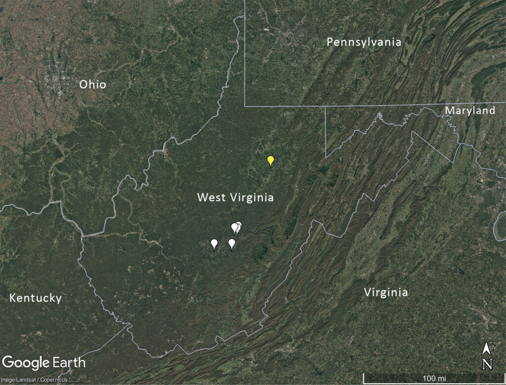
A 29-acre (12-ha) recently reclaimed coal refuse impoundment located in Barbour County, West Virginia was evaluated. The site has a mean elevation of approximately 470 m MSL (1,540 feet), is located within the Western Allegheny Plateau and has a mean annual precipitation of 122 cm (48 inches)3 (Figures 1 and 2).
Reclamation was completed in 2020 with a post mining land use of pasture; cattle grazing is expected in the future. The dam and surrounding terrain were cut and backfilled into the impounded fine coal refuse. The remainder of the dam crest and downstream slopes were set at a 2H:1V slope to maintain geotechnical stability, and a minimum 2% slope cap cover was placed on the backfilled impoundment to facilitate runoff. The depth of cover varied based on the bearing capacity of the fine refuse. A perimeter drain was added, and the site was seeded with a grass mixture (i.e., Dactylis glomerata, Lotus corniculatus, Trifolium pratense, Lolium multiflorum, Lespedeza bicolor and Triticum asetivum) following WVDEP4 guidance.
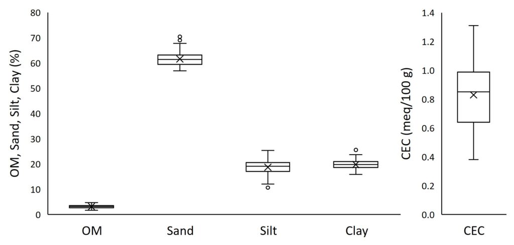
The reclaimed impoundment was characterized by field measurements. Slope was measured as 2.4% using a clinometer, and average ground cover was measured as 80.5% following guidance by Hopkinson et al.5 Composite soil samples of the top 6 inches (15.2 cm) of cover were analyzed for particle size distribution and texture classification (ASTM D2216, ASTM D854, ASTM D2487). The sandy loam had 55.0% sand, 19.8% very fine sand, 2.5% silt and 22.2% clay. Organic matter (OM = 3.9%) and cation-exchange capacity (CEC = 0.2 meq/100g) were determined by the WVU Soil Testing laboratory. Infiltration measurements were attempted; however, no measurements were possible because the site was saturated during each visit.
Sediment detachment was evaluated using the Water Erosion Prediction Project (WEPP) model with field-measured informed input parameters. Using TR-55 single storm predictions, the annual soil detachment was predicted to be 0.4 to 2.5 tons for a 2- to 500-year return period, respectively.
Then, 100 replications of the soil inputs were created, assuming normal distribution, for additional simulations (Figure 3). Sediment detachment and runoff were predicted at three slopes (2.4% as constructed, 4% and 5%) because impoundments are reclaimed with slopes to achieve drainage6, typically with low slopes. No differences in runoff were determined among varying slopes, but differences in soil detachment were predicted within the slope range of 2.4% to 5% (p ≤ 0.001); the 5% slope resulted in the greatest soil detachment.
Field Observations of Erosion
For the first five years after reclamation, a dam is considered capped/non-impounding, and regular inspections occur prior to terminating the dam license. Then, the dam may be properly abandoned with no required inspections.7 Six reclaimed coarse refuse impoundments were evaluated for evidence of erosion or instability during September 2021 through July 2022 (Figure 2).
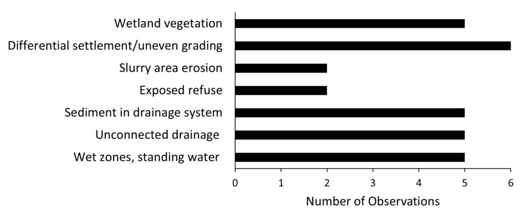
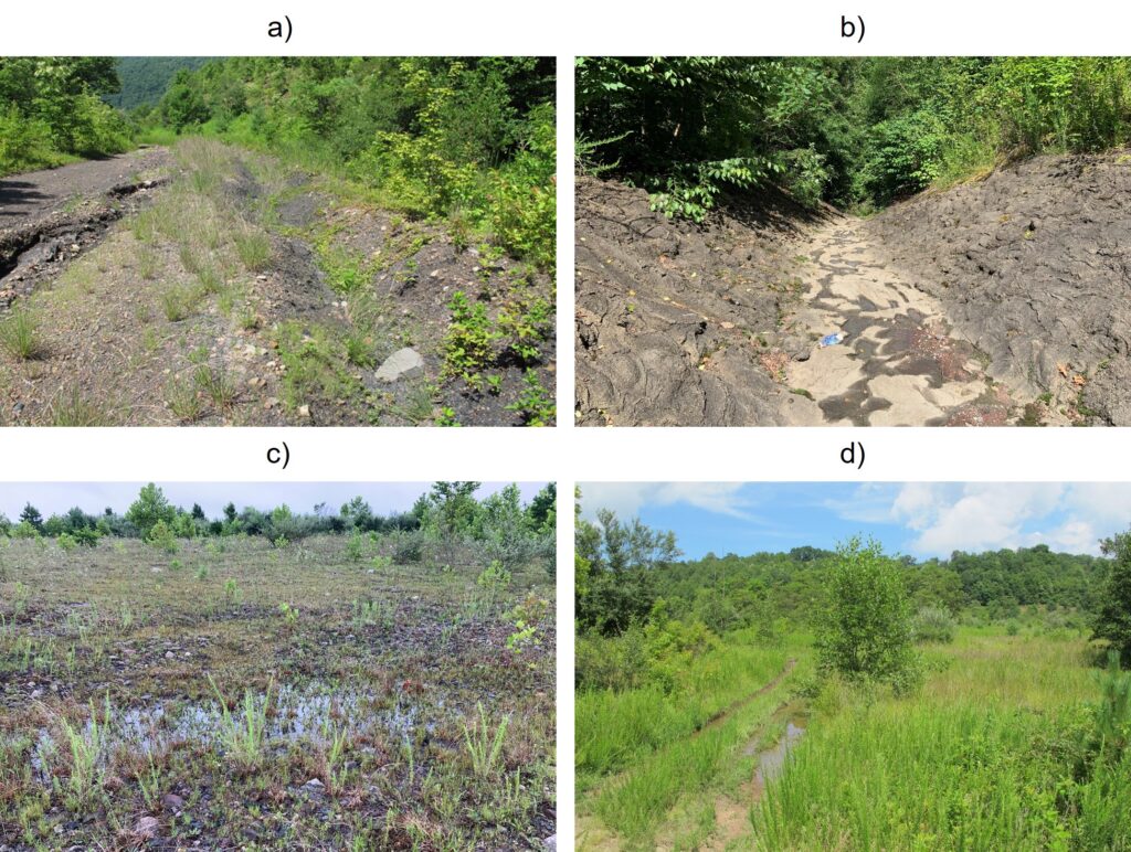
During field observations, no evidence of geotechnical instability was observed, but there were observations of erosion (Figure 4). For example, surface water found a preferential path through roads (Figure 5a) or other areas, creating gullies. In addition, sediment was observed in ditches (Figure 5b), suggesting sediment detachment.
Uneven grading and saturated conditions of the slurry material were observed (Figures 5c, d), potentially indicating insufficient drainage. Long-term stability depends on the consolidation strength of the refuse material. The strength of fine coal refuse is sensitive to moisture contents, and liquefaction may be a concern.8,1
Conclusions
Model results and field observations of erosion at recently reclaimed coal refuse impoundments showed modest sediment movement, suggesting long-term erosion may not be a concern. Field observations of six reclaimed impoundments identified saturated near surface conditions, although no indications of large slurry consolidation leading to re-impounding of precipitation water were observed. Future work may consider evaluating additional and robust perimeter and down slope drainage structures like contact ditches to offset and minimize drain blockage or damage.
References
Michael, P.R., M.W. Richmond, M.J. Superfesky, D.E. Stump, and L.K. Chavel. 2010. “Potential breakthroughs of impounded coal refuse slurry into underground mines.” Environmental and Engineering Geoscience, 16(2): 299-314.
National Research Council. 2002. Coal Waste Impoundments: Risks, Responses, and Alternatives. National Academy Press, Washington, D.C.
National Weather Service. 2020. “Local Climate Data and Plots.” National Oceanic and Atmospheric Administration, < https://www.weather.gov/rlx/climate> (accessed 3 March 2021).
West Virginia Department of Environmental Protection (WVDEP). 2016. Erosion and Sediment Control Best Management Practice Manual. Department of Environmental Protection, Division of Water and Waste Management, Washington, DC.
Hopkinson, L.C., E. Davis, and G. Hilvers. 2016. “Vegetation cover at right of way locations” Transportation Research Part D: Transport and Environment, 43: 28-39.
D’Appolonia Consulting Engineers. 2010. Engineering and Design Manual: Coal Refuse Disposal Facilities. U.S. Department of the Interior, Mine Safety and Health Administration.
Coal Related Dam Safety Rules. Title 38 38-4-21. 2003. https://dep.wv.gov/dmr/codes/Documents/Dam%20Safety%20Rules-2003.pdf (accessed 12 April 2023).
Huang, Y.H., J. Li, and G. Weeratunga, 1987. Strength and consolidation characteristics of fine-coal refuse. Annual report. United States.
Acknowledgements
This material is based upon work supported by the U.S. Geological Survey under Grant/Cooperative Agreement No. G16AP00091 and by OSM under Grant/Cooperative Agreement No. S21AC10058. Its contents are solely the responsibility of the authors and do not necessarily represent the official views of the USGS or OSM. This work was also in collaboration with the West Virginia Department of Environmental Protection.
About the Experts
Leslie Hopkinson, Ph.D., is an associate professor at West Virginia University. John Quaranta, Ph.D., PE, is an associate professor at West Virginia University. Sara Dalen, Brady Watters, and Titus Smith were graduate research assistants at West Virginia University, and Ethan Wimer was an undergraduate research assistant at West Virginia University.


