

A four-year project within Emigrant Creek, a sub-catchment of the Richmond River, showcases best practice stabilization with a goal of mitigating diffuse pollutants such as sediment and nutrients in the Richmond River Catchment in northeastern New South Wales, Australia. North Coast Local Land Services has designed and commissioned 3 km (1.86 miles) of riverbank erosion control projects using novel approaches aimed at mimicking natural recovery processes and habitat types. This has included the use of snag hotels, reef balls and corrugated log fillets to promote river stability and recovery.
The Marine Estate Management Strategy Project, funded by NSW Department of Primary Industries–Fisheries, also undertakes dirt road remediation and revegetation works to complement its river works program. Overall, 3,000 wet tonnes (3,300 US tons) of sediment have been prevented from impacting downstream marine estate habitats while protecting highly valuable agricultural land since the project commenced.
The works have also proven their resilience after recently surviving two significant flood events, approximately 20 months post construction including surcharges estimated to be 1 in 1,000-year flooding events.
Regular monitoring has highlighted that corrugated log fillets perform exceptionally well, with over 600,000 mangrove propagules naturally established at a project site in Teven within the first 18 months and over 430 m3 (15,200 feet3) of suspended sediment captured from upstream farms since construction in July 2020.
Flagship Case Study: Corrugated Log Fillets — Tea Tree Farm, Teven.
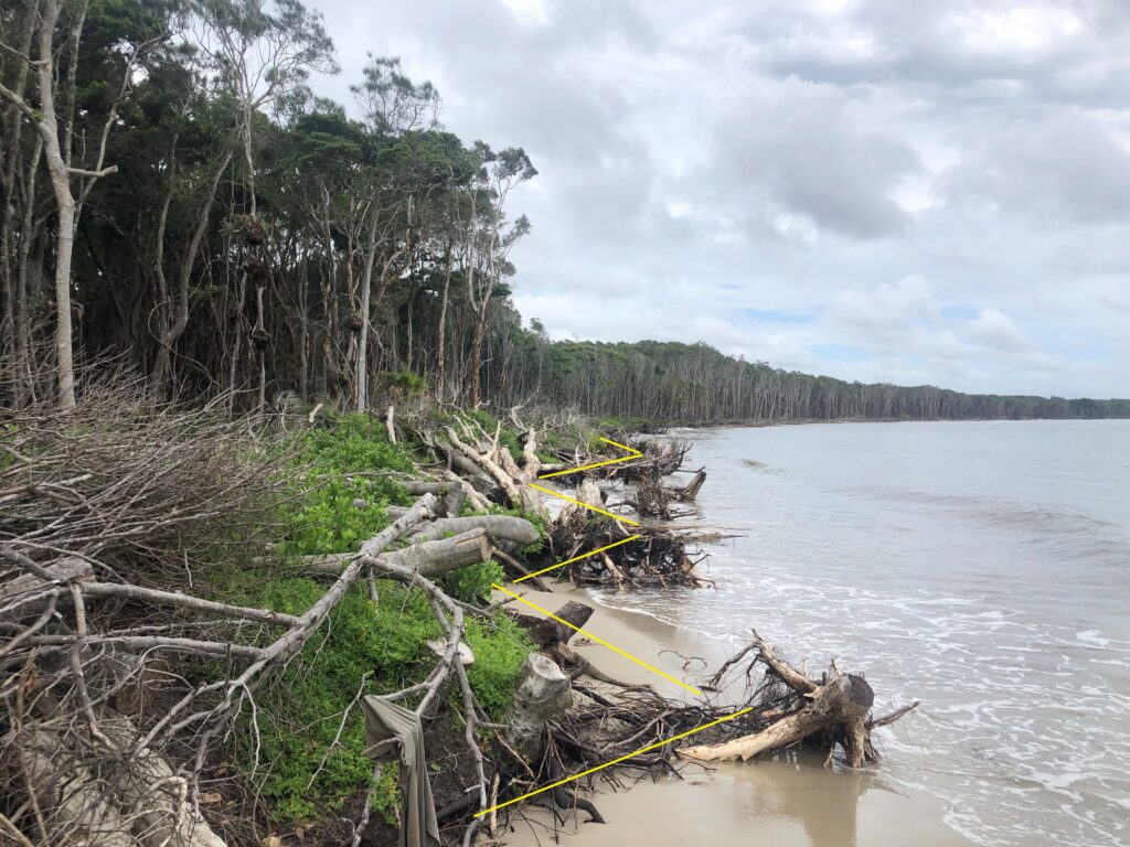
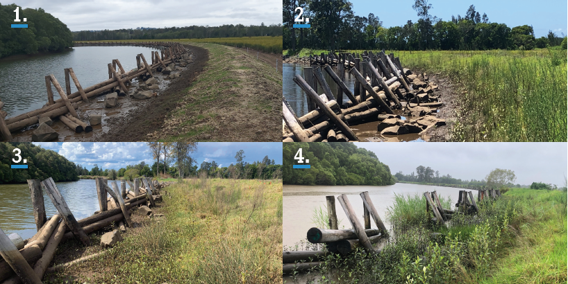
In early 2020, North Coast LLS began the design process to remediate a high-profile riverbank slumping site that exhibited a rate of erosion averaging 300 mm (11.8 inches) per flood event along 800 m (2,627 feet) of estuarine river corridor (Figure 1).
The site was located adjacent to a tea tree farm west of Ballina in the middle to upper Emigrant Creek Estuary, approximately 11 km (6.8 miles) from the confluence with Richmond River. North Coast LLS led a multi-disciplinary collaboration to have the site endorsed by key state and local government stakeholders and partner with Southern Cross University to undertake periodic monitoring.
Erosional processes were identified as meander migration, helical flows along an outside bend, fragile bank material residing on a steep angle of repose and recreational boat wash combining with a lack of vegetation to undermine bank stability.
The eroding reach, and the near-pristine mangrove-dominated opposite bank, were surveyed to identify preferred mangrove recruitment heights, species complexity, thalweg position and channel symmetry. Field assessments also assisted in identifying natural estuarine recovery processes. It was noted that if the ground elevation was suitable, a façade of mature mangroves and/or woody debris would promote the slack water habitat required to encourage mangrove propagules to establish (Figure 2).
This gave the team some real guidance towards a viable natural solution that would exceed the benefits of conventional methods such as rock fillets.
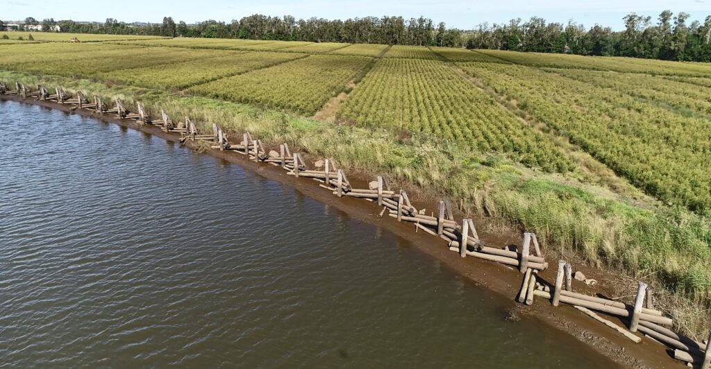
North Coast LLS then developed a concept design of a mangrove embayment area mimicking these natural recovery processes and forest settings and engaged the NSW Soil Conservation Service to administer the construction process. The concept design called for the excavation of the bank to an appropriate bed level that would promote mangrove recruitment (mean sea level), while fully utilizing the excavated material to recreate a bank shape stable enough to withstand flooding events.
A corrugated log fillet was then incorporated into the design to trap mangrove seeds and protect the nursery and newly formed bank from wave action (Figure 3). Objectives of the structure included:
- Deflect both wind and boat wash with the serrated or corrugated shape.
- Woody debris would be sustainably sourced timber and act as habitat.
- Create additional interstitial gap habitat complexity with micro-habitats in the form of rock pockets.
- Recruit mangrove seeds within the embayment area at multiple tidal heights.
- Promote significant carbon capture opportunity.
- Increase instream roughness to promote deposition of suspended sediment and nutrients.
- Tidal flux would buffer acid sulphate soils until adequate ground cover was achieved.
Corrugated log fillets primarily aimed to deflect boat wash but also provided the opportunity for surcharging flows from floods to be directed away from the bank edge. Roughness is a key geomorphic feature that has been lost in Australian rivers following European settlement. Historical snag removal to aid navigation and vegetation lost due to poor land management practices promotes ongoing issues for river management across NSW.
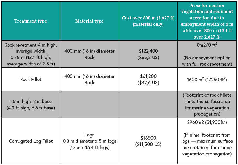
The project also sought to actively minimise the legacy traits associated with conventional rock works. There were notable benefits to this approach including reduced costs (Table 1).
The structure is designed to promote mangrove forest formation and maturity in the same period as the life span of its material type (native hardwoods), with the idea that once the structure decays in 20 years, a mangrove forest has formed as a living sentinel to provide ongoing bank stability, wave suppression and habitat complexity (Figure 4).
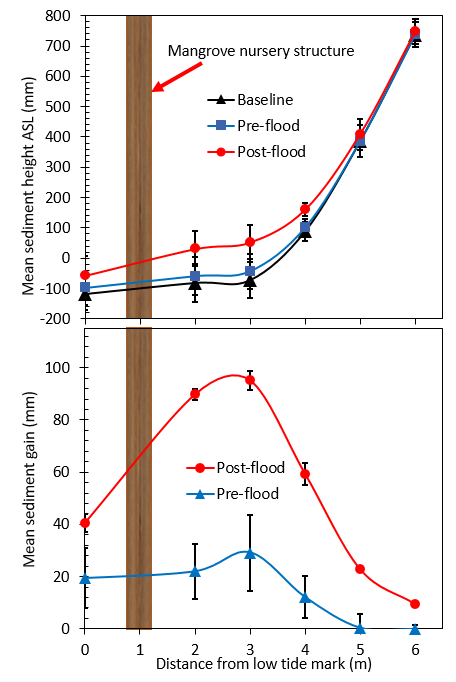
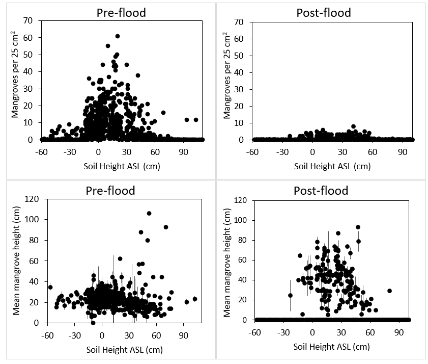
Quantifiable benefits include preventing the continued loss of bank material, estimated at 360 cu m3 (12700 ft3) or 612 tonnes (675 US tons) per flood event, onto downstream seagrass habitats. Data capture to date indicates a mean sediment accumulation rate within the embayment area of about 3.5 mm (0.14 inches) per month prior to floods (February 2022) and about 12.0 mm (0.47 inches) per month post-flood. Overall, the structure sequestered 430 m3 (15,200 ft3) or 733 tonnes (808 US tons) of suspended sediment in 24 months of sampling (Graph 1).
Although the flood period in early 2022 significantly impacted mangrove recruitment — over 90% of juveniles — the remaining 10% of the mangrove vegetation is more than sufficient to form healthy forest coverage (Graph 2). The 10% that did survive are most likely mangrove seeds that recruited into the structure in August 2020 (immediately following completion of works in July) as they had the height and strength to withstand multiple flood surcharges. This suggests that the preferred timing to finish works should coincide with known mangrove seed “drops” (July–August) to maximize recruitment potential as soon as possible. It also highlights the efficacy of corrugated log fillets to promote propagation and survival of juvenile mangroves (up 121 per m3 (10.76 ft2) prior to floods and 11 per m2 (10.76 ft2) post flood) with mature mangrove forests generally exhibiting no more than 1 tree per 4 m2 (43.06 ft2).
The site will also be analyzed at Year 4 to understand Blue Carbon, nutrient and heavy metals capture. The potential for the design to demonstrate significant sediment capture and Blue Carbon storage while attenuating floods and fertilizer runoff from upstream farms represents a more holistic approach to modern riverine management.
About the expert
Shaun Morris, M NRM, AdvDipAEM, PostGrad RR&M, CEnvP, is a senior land services officer in the Natural Assets Protection Team, North Coast LLS (NSW Government) and has accumulated over 24 years of experience developing his on-ground works portfolio across a range of freshwater and marine riverine settings.
About the Project
The Marine Estate Management Strategy (2018–2028) is funded by the NSW Government and aims to maximize the benefits the NSW community derives from coastal and marine habitats while enhancing the health of the Marine Estate. For more information visit www.lls.nsw.gov.au/MEMS.


