
The Hanalei River is an active recreation river that spans nearly 16 miles (26 km) through the island of Kauai, Hawaii, United States. The river’s base begins along Mount Waialeale, where it is engulfed by 450 inches (11.4 m) of rain annually. It eventually drains its 23-mile2 (59.5-km2) watershed into the Pacific Ocean at Hanalei Bay. With daily rains, mountain runoff and tropical storms, the banks of the Hanalei River face erosion.
In 2016, design and permitting began for a 450-foot (137-m) section of riverbank restoration at a resort and retail site in Hanalei, Kauai. While typical water velocity didn’t present a huge challenge, boat traffic, frequent storms and hau bush (Hibiscus tileaceus) plantings on the opposite bank had made a huge impact on the bank stability. Due to its lightweight wood and stringy composition, hau bush was planted by early settlers for use in rope and canoe construction. Because of its cultural significance and continued use, hau bush is still grown.
The erratic branching pattern of the hau bush makes it very difficult to remove. When unmaintained, the bushes can become invasive. In the 1970s, there was a single strip of hau bush along the western edge of the riverbank. By 2017, the bushes had spread to nearly 13.5 acres (5.5 ha) of land. The bushes engulfed a nearly 200-foot-wide (61-m) buffer along the riverbank and floodplain (Cover photo). As the bushes reached the original riverbank, the exposed roots collected debris and sediment, which allowed more hau bush to expand into the shallow banks. This expansion ultimately changed the course of the channel centerline, limited the bankfull stage of the river and added a large amount of pressure against the opposite bank on the project site. Since the original construction of the cottages and retail site 40-plus years ago, nearly 20 feet (6 m) of the bank, including an access road, has eroded.
Because of the Hanalei River’s Heritage River designation, a more natural or bioengineered approach was preferred over stone or a sea wall along the banks. After considering different options and project needs, the initial design included gabion baskets as toe protection and incorporated a vegetated geobag system of nonwoven geotextile to strengthen and encapsulate
the bank.
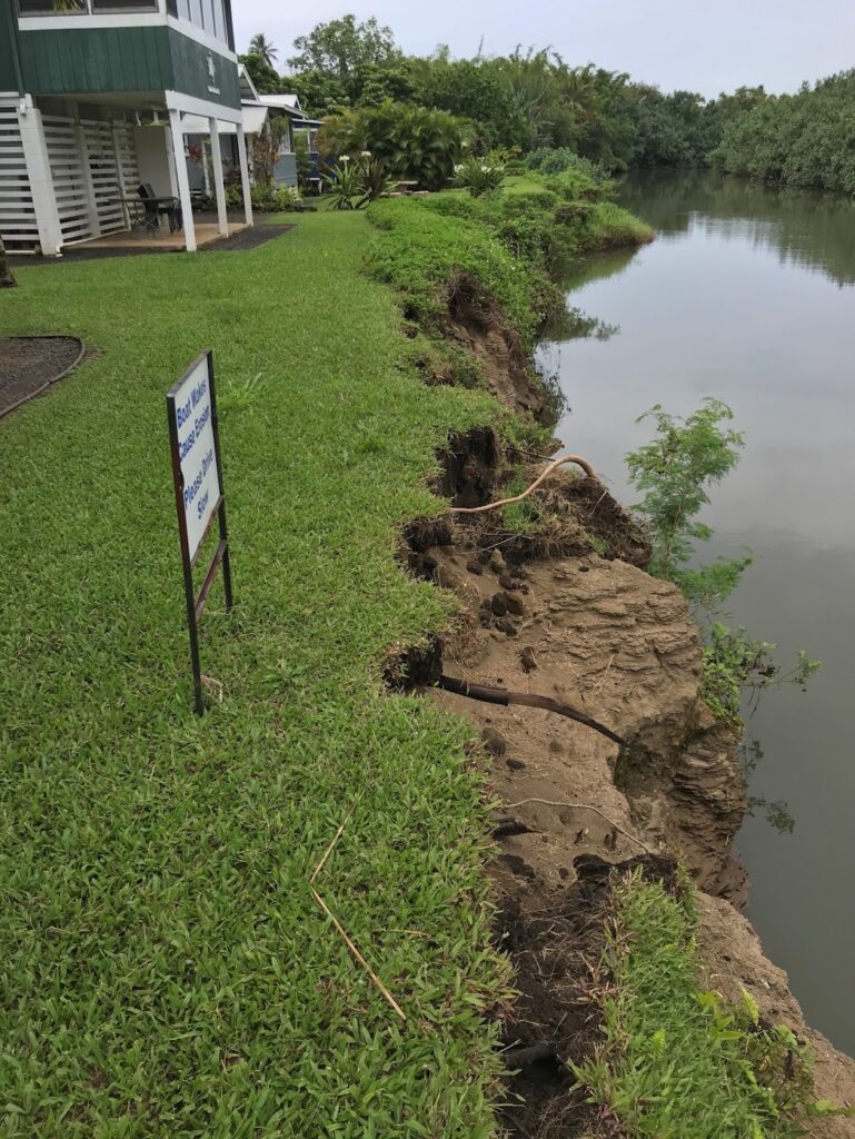
As the project team finalized the design and neared the issuing of Army Corps of Engineers, state and local permits in 2018, a tropical storm dumped 49 inches (1.25 m) of rain in less than 24 hours. This rainfall caused extensive damage along the north shore and eroded the bank to less than 3 feet (1 m) from the footings of the infrastructure (Figure 1). With the loss of additional infrastructure and flooding of buildings, the project was put on hold. The riverbank continued to erode, and the hau bush expanded its hold into the river.
In 2022, the cottages and retail site were purchased and rebranded as the Hanalei River Cottages. The design team resumed work and began to revisit site conditions and the client’s goals. The owner wanted to continue to focus on a natural aesthetic that would withstand the harsh island elements. While the general design intent stayed the same, alternative solutions to toe protection were explored.
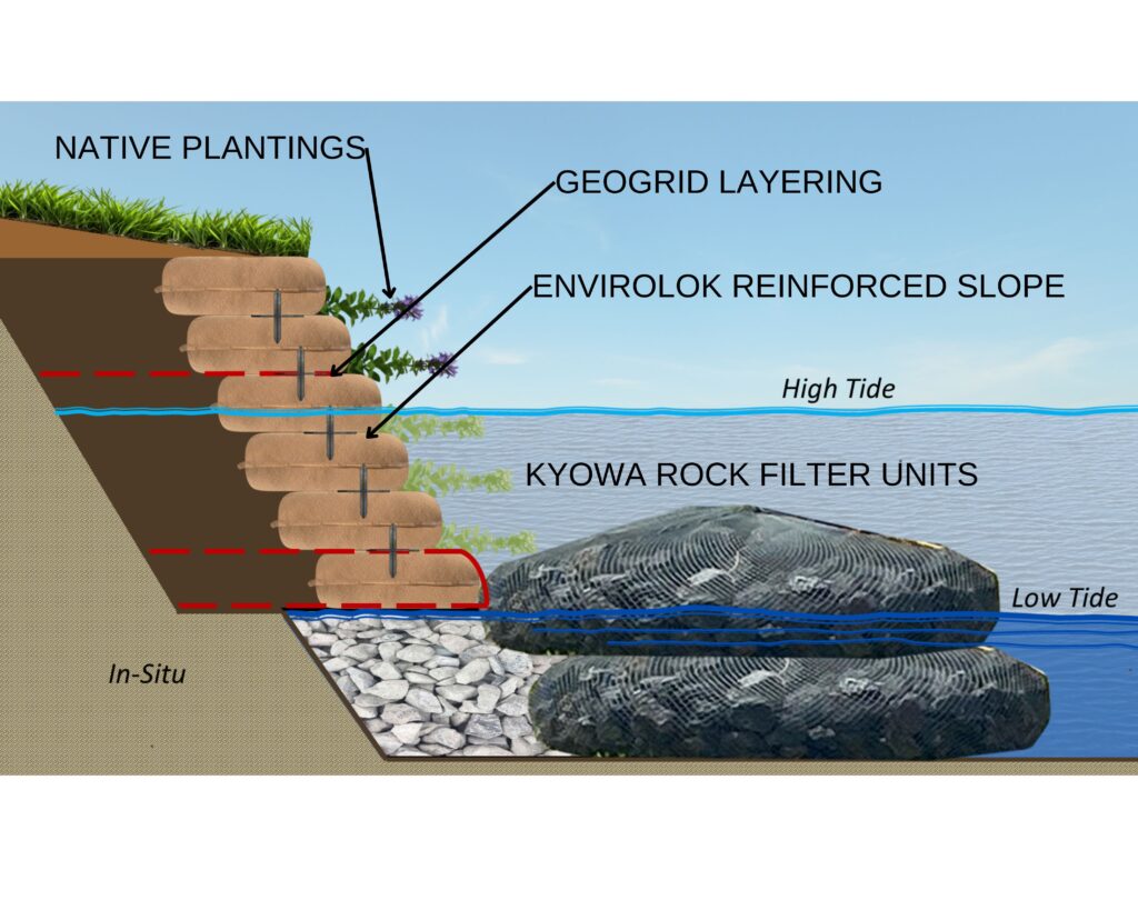
While gabion baskets have their place in slope protection, proper installation requires base prep and excavation that can be disruptive to the river channel and its ecology. The owners and the design team also wanted to avoid using gabions, as the epoxy/PVC coatings sometimes used to protect the metal cages can degrade quickly and cause pollution and habitat issues. After research and working with a local supplier, the design team proposed using Kyowa’s Filter Units as the toe protection. These “rock bags” could be filled with local stone and feature a rope/mesh system that would easily conform to the riverbed’s natural contours. In addition to these units’ strength and stability, the rope/mesh naturally collects algae and other organics. These organics attract fish and other organisms, which enhance the habitat along the river’s edge. Bags could be stacked from the riverbed up to sea level (Figure 2).
The first course of the system was installed with a geogrid wrap, just behind the top rock bag. There were 14–16 courses of geobags. This feature helps ensure that the geobag system is locked into the existing bank and will stay in place if the toe protection becomes compromised during a large storm.
By installing the geobags above sea level, a fully engineered, permanent encapsulated layer will provide stability and protection for the bank. The sand/topsoil mix used in the bag fill provides additional strength and a viable bed for plant growth, which creates a fully engineered vegetative solution.
Vegetation in any tidal zone is challenging. By working with local experts, a mix of native sedges and groundcovers were selected that would thrive in the harsh, salty conditions from wet to dry. Plant plugs from live plants were installed between the layers of geobags near the project completion.
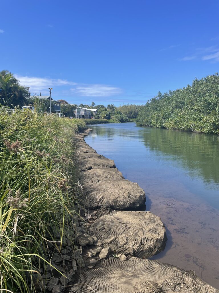
Project work began in July 2023 and was completed in September 2023. By February 2024, the geobag system was fully vegetated, and the slope project withstood a near bankfull storm event that winter. There was damage from the 2018 storm (Figure 3), but full vegetation was established after restoration in February 2024. In April 2024, 5-plus inches (12.7 cm) of rain fell in two hours, which raised the river to 1 inch (2.5 cm) above the bank. While 90% of the project withstood the river forces, a small section of the toe protection and bank were damaged. Repair work included 40–50 more rock bags being added to the toe for reinforcement, minor bank repair and the addition of stormwater mitigation systems to limit the impact of overland flow and floodwaters that overtop the bank, as this was one of the main attributes to the damaged bank.
Construction wasn’t easy. Limited access to updated site information left many unanswered questions and required a design-build approach. Working in a tidal environment with frequent daily rains created constant wet conditions and a limited window for construction. Site access was also a challenge. Much like most riverbank repair projects, the construction footprint was limited, and steep slopes required a fair amount of manual labor.
Getting materials proved difficult. Historic bridges span the many waterways that intersect the Kuhio Highway, and they have limited weight capacities and allow only one traffic lane. This situation meant creating a material staging location near one bridge where materials could be dropped off by large trucks. Smaller trucks would bring daily material loads that would work with the limited capacity of the Hanalei River Bridge. Considering the need for over 100 rock bags, 4,000 geobags, plus various fill and removal materials, deliveries were constant. Weight capacities limited the project to single deliveries of three rock bags and up to five pallets of filled geobags at one time.
Just after the construction started, local citizens, nonprofits and government agencies, including The Housing and Land Enterprise of Hawaii County (HALE o Hawaii), began exploring funding opportunities to sponsor removal, revegetation and maintenance of the 20-plus acres (8 ha) of hau bush along the river from the Hanalei Bridge to Hanalei Bay. Their diligence paid off and, with the help of state Representative Nadin Nakamura, federal and state grants were achieved to support this work. Many private donors, including owners of the Hanalei River Cottages, also helped fund the project.

In October 2024, a contract was awarded to Cushnie Construction for removal of 13.5 acres (5.5 ha) of hau bush along the north bank of the river, across from the cottages. The removal has since been completed (Figure 4). The open land has been reseeded with native vegetation, and the expectation is that it will be properly maintained over time. With the bush roots no longer collecting sediment and returning the northern bank into flood plain, the river will return to its natural channel and extensive flood plain. This return will reduce the erosive pressures from reaching the southern banks along the cottages and allow the natural river ecology to return.
About the Expert
Eric Seidl, LEED-AP, WEDG, is the technical director for Envirolok. Eric lends his expertise to developing vegetative solutions for slopes, waterways and shorelines.
Partners
- JG Consulting
- Ka’iwa Construction
- Summation Partners, LLC
- Sustainable Resources Group


