

Unmanned Aerial Vehicles (UAVs) and Unmanned Aerial Systems (UASs) — also known as drones — are quickly becoming one of the top 21st century tools utilized by the construction industry. Use of drones is not only worldwide, but also goes beyond our planet to the recent NASA Perseverance Rover Mission on Mars.
Donald Pearson, a long-time partner of the IECA Southeast Chapter USA, shared his experience working with drones in North Carolina for this article.
Why Are Drones Gaining Popularity?
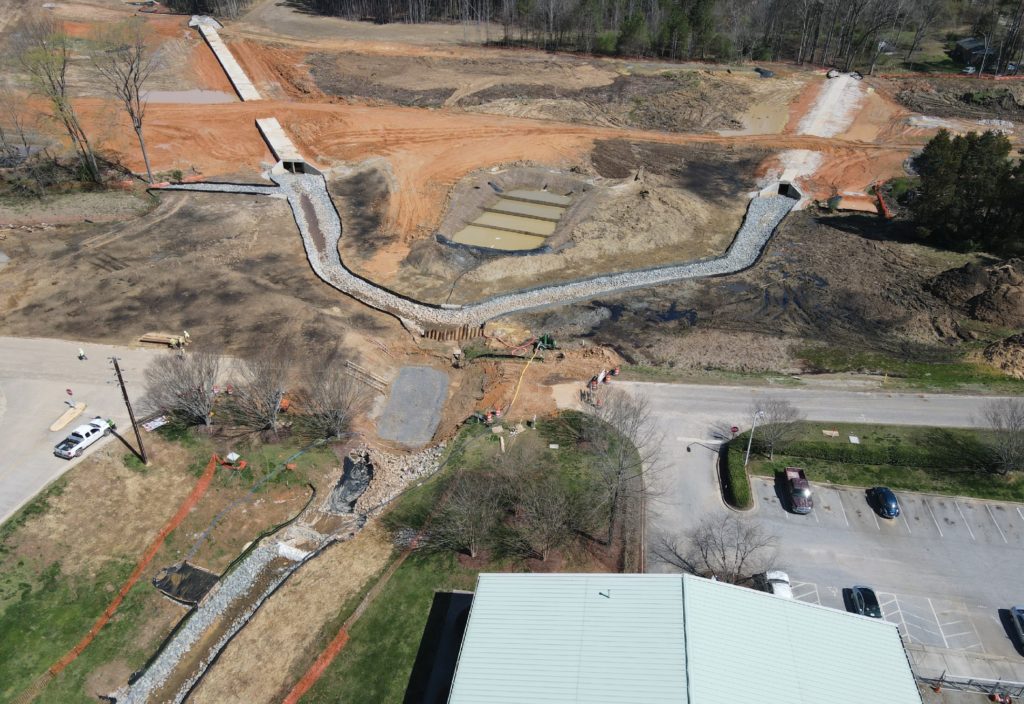
Pearson’s first experience with drones was when he was working with North Carolina State University’s Richard McLaughlin, Ph.D. and Rob Austin, a crop and soil science GIS specialist, on a research project. A drone was flown over a large borrow pit being used for the future East End Connector, a highway in Durham, North Carolina, United States. The drone’s LiDAR imagery quickly identified problems with the installed skimmer basin and the associated temporary diversion berms. The LiDAR imagery showed trails of migrating sediment associated with stormwater runoff indicating that the temporary diversion berms were becoming a much larger problem for the contractor. Images from the drone provided a unique perspective on what was happening on the ground. While erosion and sediment control professionals understand the value of photographs to document and demonstrate compliance, drone images greatly increase the ability to identify BMP failures and better design solutions (Figure 1).
Worldwide Requirements
Before launching drones to take photos and collect data at construction sites, the operator must have proper education and training, and secure official certification and drone registration from the appropriate aviation authorities for the region or country in which the drone will be operated. Although the United States Federal Aviation Administration (FAA) does not require purchase of insurance, operators and contractors should consult with their insurance carriers to ensure they have appropriate liability, cybersecurity and property insurance coverage.
In the United States, the FAA requires a drone pilot to go through the FAA certification educational training and pass an exam prior to officially operating a drone for commercial use. Similarly, in Australia the Civil Aviation Safety Authority requires education and certification under the Remote Pilot Aircraft laws and licensing requirements.
The European Union Aviation Safety Agency has just updated their regulations with the 28 member states of the European Union with similarities to other nations around planet. Each region, such as the United Kingdom, Europe, Asia, Africa, Oceania as well as North, Central and South Americas and many of their individual nations have their own specific education certification requirements, drone registrations and rules to follow in the field. For example, in most countries, a common maximum height rule is 400 feet, or 120 meters, above the ground. However, in the Antarctic, the National Science Foundation has prohibited the use of UAVs in the U.S. Antarctic Program until a formal policy is in place due to the sensitivity of the continent’s wildlife.
Before purchasing a drone for use on a project, be sure to investigate the requirements to obtain a “pilot’s license” and register the drone. It is not really a license; it is an airman certificate and the journey to obtaining it can be very challenging. In the United States, FAA regulates the use of UAVs and requires an operator using an UAV for commercial purposes to not only pass a knowledge test, but also register the UAV. Pearson found that his home state of North Carolina has an additional requirement to obtain an operator permit for commercial purposes from the North Carolina Department of Transportation, Aviation Division.
Always check the aviation authority’s website for proper guidance. In the United States, consultants, engineers and contractors can visit www.faa.gov/uas/commercial_operators/. Review 14 CFR Part 107 before launching a drone on a construction site or work project. According to this rule, if the drone is less than 55 pounds, it can be flown for work or business under the guidelines of Part 107.
Additionally, do not forget to create an account and register the drone at www.dronezone.faa.gov. Registration costs $5 U.S. and is valid for three years. Once it is registered, the drone must be marked with the registration number in case it gets lost or stolen. Learn more about registration and marking requirements for drones in Small Unmanned Aircraft, 14 CFR part 48. There are many supporting companies to assist in preparations for the knowledge test, however it is not necessary to utilize a third party.
Uses for Drones Today
Pearson is using drones in the following situations:
- Identification of environmentally sensitive areas marked by boundary fencing or flagging.
- Review BMP installation to compare with approved erosion and sediment control plans or SWPPPs (Figure 2).
- Assess drainage areas during construction to determine if BMPs are being over- or under-utilized.
- Video documentation of BMPs for post weather events, with reference to video time stamp to prioritize urgency levels.
- Reconnaissance of high risk or sensitive areas immediately after weather event for crew assignment.
- Reconnaissance in wetland areas where beaver impoundment is suspected.
Future Uses of Drones
- For permanent vegetation density assessments.
- To satisfy permit requirements.
- For turbidity level assessments in sediment basins or private ponds adjacent to work locations.
- Obtain preliminary construction turbidity conditions of private ponds.
Non-Environmental Uses
- Inspection of bridge components like bearing pads, nuts and bolts. This eliminates the need for a bucket truck or long ladders.
- Lighting intensity inspections for roadway or interchange locations.
- Topographic surveys to quantify earthwork movement.
- Provide unique view point of concrete bridge deck pours and activities of key personnel in that operation.
- Document existing conditions for areas when planning for site development.
- Assess right of way or easement impacts from temporary activities on the ground.
Pearson’s current project is 18 miles (29 kilometers) of new interstate located in central North Carolina. The project involves the movement of 11,000,000 cubic yards (8,410,107 cubic meters) of soil, the construction of 52 bridges and 33 culverts and the installation of over 1,500,000 square feet (92,093 square meters) of noise wall. All of this is being accomplished by a contractor and inspection staff experiencing a limited workforce in both numbers and experience due to the long-term effects of the COVID-19 pandemic. UAVs are just one tool that supports environmental inspectors on-site as they try to keep up with the contractor’s schedule.
Thinking outside the box is especially necessary for large projects when it comes to providing oversight on erosion and sediment control. Consider the unique perspective an elevated view could and does offer. Another essential support for oversight is data interpretation and GIS personnel. A lot of things are possible with drones but without these skilled data interpretation and GIS personnel, you can only get a bunch of pretty pictures. So, keep in mind that when a company is planning to add a company drone and certified pilot that these important support personnel are needed to maximize the value of drone imagery.
Resources
- African countries, https://drone-laws.com/drone-laws-in-african-countries/.
- Asia and Drone Friendly Countries, https://www.drone-made.com/post/asia-drone-laws.
- Australia, Civil Aviation Safety Authority, https://www.casa.gov.au/drone.
- Canada, Transportation Canada Civil Aviation (TCAA), https://drone-laws.com/drone-laws-in-canada/.
- Central American countries, https://www.centralamericadata.com/en/search?q1=content_en_le:%22drones%22.
- European Union Aviation Safety Agency https://www.easa.europa.eu/the-agency/faqs/registration-requirements.
- Mexico, https://drone-laws.com/drone-laws-in-mexico/.
- South America, https://drone-laws.com/drone-laws-in-south-american-countries-2/.
- United Kingdom: https://uavsystemsinternational.com/pages/united-kingdom-drone-laws.
- United States Department of Transportation, Federal Aviation Authority, https://www.faa.gov/uas/getting_started/register_drone.
- Worldwide list and map: https://www.drone-made.com/drone-laws.
About the Experts
Donald Pearson, EI, CPESC is an Assistant Resident Engineer with Summit Design and Engineering Services located in North Carolina.
Stefano Rignanese, PE, is technical marketing manager NA, with Maccaferri USA.
Hal Lunsford, MPA, president and owner of Lunsford Environmental LLC, environmental education, and consulting services, southeast United States and primarily in Florida.


