

Improving Stormwater Treatment and Restoring Environment
By Matt Williams, AALA, OALA, CSLA
Dale Hodges Park is a transformative landscape along the Bow River in the City of Calgary, Alberta, Canada. The project began with the need to restore the environmental health of the area while addressing stormwater treatment opportunities for runoff from over 1,700 hectares (4,200 acres) of adjacent urban area.
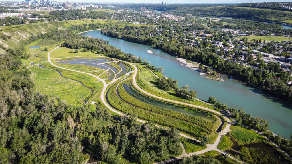
Once a gravel quarry located within an existing 164 hectare (405 acre) river valley park, the site adds 40 hectares (100 acres) of integrated park land, stormwater treatment facilities and one of the largest public artworks in North America. Calgary’s leaders had the foresight to see this project as an opportunity to combine green stormwater management practices with park and arts amenities to create a unique experience for residents. The park concept follows the journey of stormwater through a series of experiences that emphasize the flow of water through the landscape. The project enables citizens to see how stormwater is managed and aims to inspire curiosity and a deeper understanding of how natural and manmade systems interact.
Actual construction began in late 2015, and the park opened to the public in June 2019. Total cost of the project was $26.8 million, with design and construction of the stormwater treatment system representing $19.4 million of the total. Funding was shared by the City of Calgary’s parks, water resources and public art departments.
The project was led by Watershed+, a city program that embeds artists within infrastructure projects. A multidisciplinary team comprised of landscape architects and park designers, civil engineers and stormwater wetland designers worked collaboratively with the artists from Watershed+ to fulfill the functional and artistic intentions of the project. The multidisciplinary approach allowed each discipline to build upon the team’s collective knowledge and creativity to achieve the outcomes demanded by the City of Calgary for this incredibly valuable and strategic park.
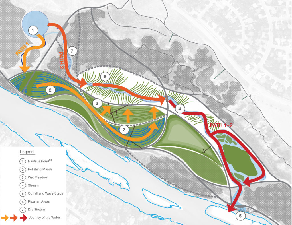
This project is unique in that the team embraced the requirement for stormwater treatment as an opportunity to explore and create new experiences for park users and a diverse range of upland, riparian and aquatic habitats. The focus was to show the movement of stormwater through the site and make its journey apparent at each treatment stage. This is accomplished through the formal design of the system and through interventions that allow for a visceral experience of the water’s movement.
The stormwater story begins when the water emerges at the source walls, an energy dissipation structure that makes a spectacle of the velocity of the water as it enters the system. The water then goes through a high performance surface water treatment environment, an innovative circular clarifying pond that is the primary mechanism for removing the total suspended solids (TSS) from the stormwater before it enters the wetland treatment cells. From there, water cascades through built structures and streams into a series of polishing marshes, wet meadows, riparian areas and a 900m (3,000 ft) long restored stream. The built structures, streams and marshes were designed with the intention to bring the water to the surface and demonstrate the water’s movement and energy in that moment of the treatment cycle (Figures 1 and 2).
In a typical year, this system is estimated to remove 85,000 kg (190,000 lbs) of TSS that would otherwise be discharged to the Bow River. The TSS is regularly removed from the surface water treatment pond, which is easily dewatered to allow equipment to remove the sediments and haul to an approved waste facility. As this is the first forebay of its kind to be constructed in Calgary, the maintenance regime will be developed through regular monitoring of the sediment accumulation. Based on the first few years, the sediment will likely need to be removed annually, which means the forebay is performing more efficiently than expected.
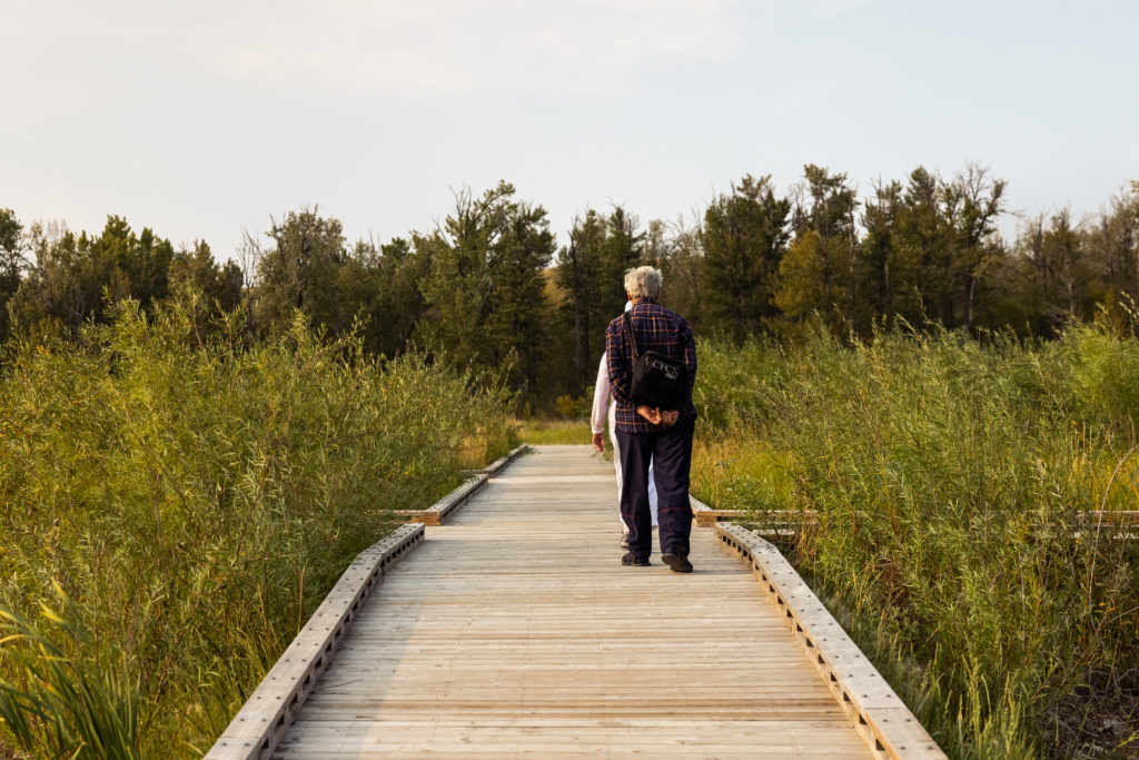
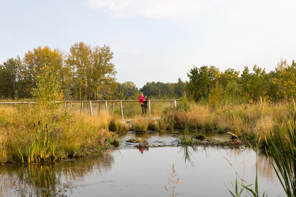
Riparian morphological forms inspired the design of the park, creating opportunities for water treatment and interpretation of the landscape patterns. The polishing marshes follow sweeping curves reminiscent of anabranches and river scrolls that evolve when a channel diverges and rejoins a river. A pathway along a scroll provides access to the water while elevated, crisscrossing boardwalks contrast the elegance of the natural patterns, evoking fallen floodplain trees strewn by the current (Figure 3). The emergent vegetation zones throughout the marshes provide additional filtration and critical waterfowl habitat. The outlet stream is a restored seasonal creek that mimics alluvial side channel formations and discharges to an important trout rearing habitat in the Bow River, serving as fish refuge during river flood conditions (Figure 4).
The restoration of the abandoned quarry presented numerous challenges and opportunities for the project. Contamination, poor soils and invasive species were prevalent and required an enormous overhaul of the site’s basic substrate while preserving and enhancing existing forested and vegetated areas. Planting included nearly 50,000 woody and 40,000 emergent plants, and establishment was largely successful except for some emergent plants that were inundated above design levels for a period. This has created a unique open water condition in one cell that actually provides more diverse habitats.
Floating wetland technology was introduced in the first wetland treatment area. The innovative system floats wetland plants in a PVC “basket” to create additional habitat and filtration. Another amazing component of the project, that had significant influence on the project, was the restoration of a 900 m (3,000 ft) long seasonal creek that flowed through the land prior to mining operations.
The historic stream alignment was identified through research of historical aerial photographs and analysis of the site’s topography. The forest stream was integrated into the stormwater journey as one flow path for water exiting the surface water treatment pond. The mirror pool was installed at the head of the stream, letting water gently fall into its course through the forest and then out into the main park area where it flows through sculpted terrain inspired by riparian patterns that provides diverse upland habitat. Water from the park’s primary treatment cells then reconnect with the stream before the entire system enters the Bow River. The stream’s form and function became a launching point for design inspiration and restoration principles.
Implementation of the project has resulted in numerous positive impacts. The project’s robust public and stakeholder engagement process has led to widespread public praise of the finished park. Ecological systems in the park are now rich and diverse, visible in the prevalence of native vegetation and wildlife. As a new type of high-performance public space, the park achieves multiple infrastructure requirements through a beautiful open space, providing ecosystem services and enhancing the quality of everyday life.
About the Expert
Matt Williams, AALA, OALA, CSLA, is a landscape architect and principal at O2 Planning & Design, based in Calgary, Alberta, Canada.
Project Note: The Dale Hodges Park project was a multi-disciplinary collaboration led by the City of Calgary and included artist practice Sans façon for Watershed+, O2 Planning & Design, Source2Source and AECOM.


